Synopsis:
A slow rebound in temperatures will begin today as high pressure slips off the coast and a Southwest wind develops. The sun will dominate. By Friday, readings be several degrees above with a milder push of air. The average high temperature is 53º.
The weekend at this time looks decent. Another area of high pressure will move into Northern New England on Saturday. The cold air with this system will remain to our North but supply the region with abundant sunshine. It will be mild. Sunday will feature more clouds with readings just above average as moisture works in off the ocean.
A few showers are possible on Monday with an approaching front.
Stay Tuned.
Keep it here for a no nonsense, no hype forecast.
Today:
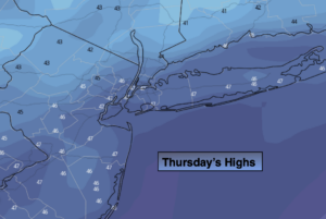
Mostly sunny. Chilly. Highs in the upper 40s. Southwest winds at 5-10mph.
Tonight:
Partly cloudy, not as cold. Lows in the lower 40s in the City, the upper 20s and 30s inland. Southwest winds at 5-10mph.
Friday:
Mostly sunny. Milder. Highs in the upper 50s.
Saturday:
Mostly sunny. Mild. Highs around 60º.
Sunday:
Clouds, some sun. Highs in the mid 50s.
Monday:
Clouds, some sun. Scattered showers. Highs in the mid 50s.