Synopsis:
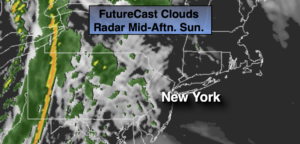
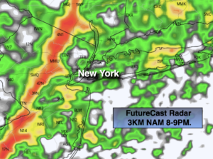
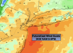
Today will be a decent day. I am holding off the showers until sunset or after. A mix of sun and clouds is expected. A significant cold front will approach during the evening. This will increase the wind by mid-afternoon. As the front approaches during the evening a squall line will accompany it between 7p and 9pm (2nd map above). A quick shot of heavy rain and possible thunderstorms will move through. Winds will gust between 40 and 50mph (3rd map). Temperatures will be at the highs for the day during the evening before the front moves through. Temperatures then will fall rapidly on a strong Northwest wind.
Skies will clear tonight it will be breezy.
Monday through Wednesday will be dry but getting progressively colder as a dominant Northwesterly flow prevails from Canada. The wind will add a bite to the chill. Readings by midweek will be at least ten degrees below the average high of 54º. A mix of sun and clouds is expected.
A slow rebound in temperatures will begin on Thursday as high pressure slips off the coast and a Southwest wind develops. The sun will continue to dominate.
Stay Tuned.
Keep it here for a no nonsense, no hype forecast.
Today:
Sun and clouds. Becoming windy. Highs in the upper 50s to lower 60s by evening. Southeast to South winds increasing to 15-25mph during the afternoon with gusts to 40mph after 3pm.
Tonight:
Showers and storm will move through this evening along with strong winds. Skies will clear later this evening and winds will ease some overnight. Lows in the mid 40s in the City, the 30s inland. West wind at 15-25mph.
Monday:
Mostly sunny and breezy. Highs in the lower 50s.
Tuesday:
Partly sunny, breezy and chilly. Highs in the upper 40s.
Wednesday:
Mostly sunny. Cold. Highs in the lower 40s.
Thursday:
Sunny. Chilly. Highs in the upper 40s.