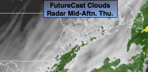
Synopsis:
A cool front will slowly move through the region tonight. Scattered showers and areas of heavy rain will continue. The heaviest rain will be along the coast. Thursday will be damp to start as the front stalls just offshore. Scattered showers are likely during the morning with a steadier rain along parts of the immediate coast. Drier air will work in behind the front and any leftover showers will taper off from Northwest to Southeast during the day. Skies will remain cloudy with possibly some dim sun from time to time. Temperatures will remain in the 50s as cooler air works in. Readings will be close to the average high by days end (which is 55º).
On Friday, a weak disturbance moving along the coast will once again bring the threat of showers. The timing looks to be a few hours of either side of midday. The day may end with a few hours of sun.
High pressure will nose in from Eastern Canada on Saturday resulting in a bright but cool day. Sunday may start off sunny, but a frontal system moving toward the region during the afternoon will increase the clouds but at this time the daylight hours look dry.
Stay Tuned.
Keep it here for a no nonsense, no hype forecast.
Tonight:
Scattered showers with heavier areas of rain along the coast. Lows in the 50s throughout. South to Northwest wind at 5-10mph.
Thursday:
Morning scattered showers tapering off from Northwest to Southeast during the day. Remaining cloudy. Highs in the 50s. South to Northwest winds at 5-10mph.
Friday:
More clouds than sun. Scattered showers. Highs in the mid 50s.
Saturday:
Sunny and seasonal. Highs in the lower to mid 50s.
Sunday:
Sun and clouds. Highs in the upper 50s.
Monday:
Partly sunny and breezy. Highs in the mid to upper 50s.