Synopsis:
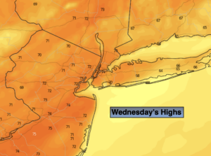
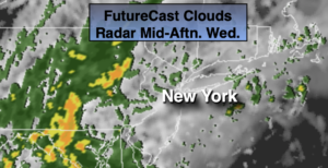
We’ll do it one more time with near record warmth for the 4th consecutive day today. It’ll be balmy and you’ll notice an increase in the humidity. Any rays of morning sun will give way to cloudy skies with scattered afternoon showers as a cool front approaches. The unusually warm pattern will break down slowly the next 36 hours. A period of steadier and heavier rain is likely later this evening and tonight. We’ll need to monitor where that axis sets up. Thursday will be damp to start as the front stalls just offshore. Scattered showers are likely during the morning with a steadier rain at the coast. The showers will taper off from Northwest to Southeast during the day Thursday. Temperatures will remain in the 50s as colder air works in. Readings will be close to the average high by days end (which is 55º).
On Friday, a weak disturbance moving along the coast will once again bring the threat of showers. The timing looks to be a few hours of either side of midday.
High pressure will nose in from Eastern Canada on Saturday resulting in a bright but cool day. Sunday may start off sunny, but a frontal system moving toward the region during the afternoon will increase the clouds but at this time the daylight hours look dry.
Stay Tuned.
Keep it here for a no nonsense, no hype forecast.
Today:
Mostly cloudy. Balmy. Chance of afternoon showers. Highs in the lower 70s. The record is 74º set in 1949 for Central Park. South winds at 10-15mph.
Tonight:
Periods of rain. Heavy at times. Lows in the 50s throughout. South to Northwest wind at 5-10mph.
Thursday:
Morning rain tapering off from Northwest to Southeast during the day. Highs in the 50s.
Friday:
More clouds than sun. Scattered showers. Highs in the mid to upper 50s.
Saturday:
Sunny and seasonal. Highs in the lower to mid 50s.
Sunday:
Sun and clouds. Highs in the upper 50s.