Synopsis:
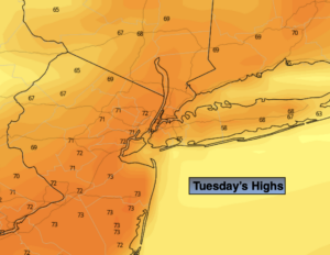
Indian Summer will continue for a few more days. Patchy morning fog will give way to mainly sunny skies. High pressure remains anchored off the Eastern seaboard and continues to pump up our Spring-like readings. Record warm temperatures will once again be approached today. The record for Central Park is 73 set in 1985. It will be close. It will be much cooler along the immediate coast.
Skies will become mostly cloudy tonight with patchy fog redeveloping. It will be warm with readings around 60º for lows in urban areas. That’s five degrees above the average high of 55º!
The pattern will break down slowly tomorrow and Thursday. This will allow a cool front to approach with the chance of showers Wednesday afternoon into a part of Thursday. Wednesday will be balmy and you’ll notice an increase in the humidity. Temperatures will slip into the 60s by Thursday.
On Friday, the front will clear the coast and allow for more fall-like conditions along with some sunshine. By Saturday, temperatures may actually be a couple degrees below the average high. The sun will rule the sky.
Stay Tuned.
Keep it here for a no nonsense, no hype forecast.
Today:
Patchy morning fog, otherwise mostly sunny. Near record warmth. Highs in the lower 70s. Cooler at the coast. South to Southwest winds at 5-10mph.
Tonight:
Becoming mostly cloudy. Unusually warm. Lows in the lower 60s in the City, the 50s inland. Light South to Southwest wind.
Wednesday:
Mostly cloudy. Balmy. Chance of afternoon showers. Highs around 70º.
Thursday:
Showers through midday. .A bit of afternoon sun. Highs in the mid 60s.
Friday:
Clouds & sun. Cooler. Highs in the upper 50s.
Saturday:
Sunny and seasonal. Highs in the lower to mid 50s.