Synopsis:
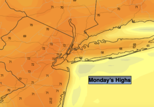
Indian Summer will continue for several more days. The sun will dominate through Tuesday. High pressure remains anchored off the Eastern seaboard pumping up our Spring-like readings. Record warm temperatures will once again be approached today. The record for Central Park is 75 set in 1975. It will be close. Temperatures will be almost twenty degrees above the average high of 56º. It will be much cooler along the immediate coast.
The pattern will break down midweek and this will allow a cool front to approach with the chance of showers Wednesday afternoon into a part of Thursday. Temperatures will slowly slip into the 60s by this time.
By Friday, the front should clear the coast and allow for more seasonal temperatures along with some sunshine.
Stay Tuned.
Keep it here for a no nonsense, no hype forecast.
Today:
Sunny. Warm. Highs in the lower to mid 70s. Winds becoming South less than 5mph.
Tonight:
Mostly clear. Mild. Lows in the upper 50s in the City, the 40s inland. Light Southwest to West wind.
Tuesday:
Mostly sunny. Very mild. Highs in the upper 60s.
Wednesday:
Mostly cloudy. Balmy. Chance of afternoon showers. Highs in the upper 60s.
Thursday:
Mostly cloudy. Morning Rain. Highs in the mid 60s.
Friday:
Clouds & sun. More seasonal. Highs in the upper 50s.