Synopsis:
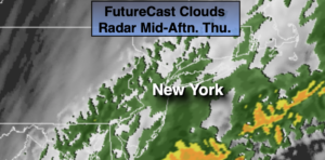
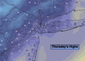
Today is the transitional day between the six consecutive days of 70º+ readings days to typical November conditions. This mornings highs of the 60s will be a mere memory as a cold front has moved offshore. Readings will fall into the 50s along the urban corridor to the 40s inland for afternoon highs. Scattered showers are likely during the morning with a steadier rain along parts of the immediate coast. Drier air will work in behind the front and any leftover showers will taper off from Northwest to Southeast during the day. Skies will remain cloudy.
Tonight will be cloudy and much cooler than the last several nights. A spot shower can’t be ruled out.
On Friday, a weak disturbance moving along the coast will once again bring the threat of showers. The timing looks to be a few hours of either side of midday. The day may end with a few hours of sun.
High pressure will nose in from Eastern Canada on Saturday resulting in a bright but cool day. Sunday may start off sunny, but a frontal system moving toward the region during the afternoon will increase the clouds but at this time the daylight hours look dry.
Stay Tuned.
Keep it here for a no nonsense, no hype forecast.
Today:
Scattered showers tapering off from Northwest to Southeast during the day. Remaining cloudy. Afternoon highs in the 50s, falling into the 40s inland. South to Northwest winds at 8-12mph.
Tonight:
Cloudy with a spot shower possible. Much colder than recent nights. Lows in the mid 40s in the City, the 30s inland. Northeast wind at 5-10mph.
Friday:
Cloudy. Scattered showers. Peek of late day sun possible. Highs in the mid 50s.
Saturday:
Sunny and seasonal. Highs in the lower to mid 50s.
Sunday:
Sun and clouds. Highs in the upper 50s.
Monday:
Partly sunny and breezy. Highs in the mid to upper 50s.