Synopsis:
High pressure will continue to move off the Northeast coast today. A return flow off the ocean will result in a mix of clouds and sun. Spotty drizzle may occur, mainly near the coast, but this won’t be a big deal. Generally speaking a decent Sunday is expected. Readings will be seasonal. The average high is 77º.
Monday will be warm under mostly sunny skies. A significant cool front will move through by Tuesday. An October preview is on the way with most readings remaining in the upper 60s. The sun will dominate through Thursday as high pressure once again dominates with moderating temperatures.
Stay Tuned.
Keep it here for a no nonsense, no hype forecast.
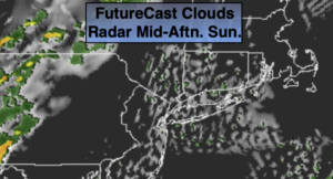
Today:
Clouds and sun. Spotty drizzle is possible near the coast. Most areas will be dry. Highs in the mid to upper 70s. Southeast winds at 5-10mph.
Tonight:
Partly cloudy. Lows in the mid 60s in urban areas, the 50s and lower 60s inland. South to Northwest winds at 5mph.
Monday:
Sunny and warm. Highs around 80º.
Tuesday:
Sunny and much cooler. Highs around 70º.
Wednesday:
Mostly sunny. Highs in the mid 70s.
Thursday:
Mostly sunny. Highs in the upper 70s.