Synopsis:
Today will be a gem. Abundant sunshine is expected with very low humidity and temperatures that will feel more like early Fall. High pressure over the Northeast is responsible for our spectacular weather.
As the high slips off the coast a return flow off the ocean will result in a mix of clouds and sun some for Sunday. Spotty drizzle may develop but this is not expected in stone. Sunday very well may turn out to be a dry decent day, despite more clouds. Readings will be more seasonal. The average high is 77º.
Monday will be warm under mostly sunny skies. A significant cool front will move through by Tuesday. An October preview is on the way with most readings remaining in the upper 60s. The sun will dominate much of next week.
Stay Tuned.
Keep it here for a no nonsense, no hype forecast.
Today:
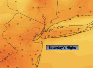
Sunny. Cool. Highs in the lower 70s. Northeast to East winds at 8-12mph.
Tonight:
Partly cloudy. Lows in the lower 60s in urban areas, the 50s inland. East winds at 5mph.
Sunday:
Clouds and sun. Spotty drizzle is possible. Highs in the mid to upper 70s.
Monday:
Mostly sunny. Warm. Highs around 80º.
Tuesday:
Sunny and much cooler. Highs around 70º.
Wednesday:
Mostly sunny. Highs in the mid 70s.