Synopsis:
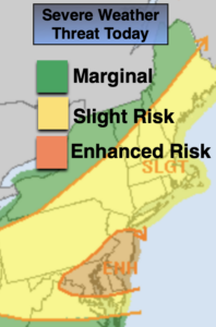
It will be hazy, hot and humid today. A significant cool front will approach during the afternoon. Scattered showers and storms are possible. Some of the storm may turn severe. Our area is in a slight to enhanced threat of severe thunderstorms (map above). Severe thunderstorms contain wind gusts in excess of 58mph and or one inch hail. Frequent cloud to ground lightning and torrential rain is likely with any storm. Not all areas will get in on the action. Keep an eye to the sky for threatening weather after 2pm.
Behind the front cooler and much less humid air will usher in tonight. It will be in the 50s inland. Time to give the AC a well deserved break.
It will be much more comfortable on Wednesday with a flow out of Canada. Readings will be below the average high of 83º and the humidity will be much lower under sunny skies. A fall feel for sure. But don’t get to used to it as warmer and more humid conditions will be back by late week as a warm front moves through. Spotty afternoon storms are possible, but much of the time will be dry under a mix of sun and clouds.
Saturday is the greatest threat for showers and storms as a cool front approaches and the remnants of tropical system Laura move through.
Stay Tuned.
Keep it here for a no nonsense, no hype forecast.
Today:
Hazy, hot and humid. Scattered PM Storms. Highs in the lower 90s. West to Northwest winds at 8-12mph.
Tonight:
Becoming mostly clear. Much cooler and less humid. Lows in the mid 60s in the City, the 50s inland. Northwest winds at 10-15mph.
Wednesday:
Sunny. Highs in the upper 70s.
Thursday:
Partly sunny, warmer and more humid. An afternoon isolated storm is possible. Highs in the mid to upper 80s.
Friday:
Hazy, warm and humid. Afternoon scattered storms are possible. Highs in the mid 80s.
Saturday:
Hazy and humid. Showers and thunderstorms are likely. Highs in the lower 80s.