Synopsis:
Spotty showers will be around this morning. It will be another hazy, hot and humid day. Scattered afternoon storms are possible but they will not be as intense as Wednesday’s storms even though a few isolated cells may go severe. Much of today will be dry.
Friday will be a bit more tolerable with it not be quite as hot or humid as a light wind from the North brings down slightly drier air.
A typical July weekend is on the way. The sun will dominate as a Bermuda high re-establishes itself. This is the weather system that results in the 3 H’s along the East coast. Saturday will be hot. Sunday will be a scorcher with high heat and humidity. The heat will spill into the beginning of next week.
Stay Tuned.
Keep it here for a no nonsense, no hype forecast.
Today:
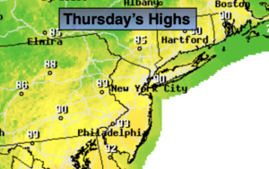
Spotty morning showers, otherwise hazy, hot and humid. Spotty PM Storms. Highs around 90º. West to Southwest winds at 8-12mph.
Tonight:
Evening spotty showers or storms, otherwise partly cloudy, warm and muggy. Lows in the mid 70s in urban areas, around 70º inland. West to Northwest winds at 5mph.
Friday:
Mostly sunny. Not as hot. Highs in the mid to upper 80s.
Saturday:
Mostly sunny. Hot. Highs around 90º.
Sunday:
Hazy, hot and humid. Highs in the lower 90s.
Monday:
Hazy, hot and humid. Highs in the lower to mid 90s.