Synopsis:
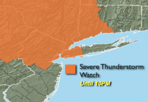
Keep an Eye to the sky for threatening weather. A Severe Thunderstorm is in effect until 10pm for most of the tri-state area excluding Suffolk, Mercer, Monmouth and Ocean Counties. The remainder of the day will be hazy, hot and humid. Scattered showers and storms will develop. Some of the storms may be severe with winds in excess of 58mph and or one inch hail. Frequent cloud to ground lighting strikes will occur along with torrential downpours. Remember these storms will be scattered and not everyone will get into the action.
The activity will wane this evening and skies will become partly cloudy overnight.
Friday will be a bit more tolerable with it not be quite as hot or humid as a light wind from the North brings down slightly drier air.
A typical July weekend is on the way. The sun will dominate as a Bermuda high re-establishes itself. This is the weather system that results in the 3 H’s along the East coast. Saturday will be hot. Sunday will be a scorcher with high heat and humidity. The heat will spill into the beginning of next week.
Stay Tuned.
Keep it here for a no nonsense, no hype forecast.
Rest of Today:
Hazy, hot and humid. Spotty PM Storms. West to Southwest winds at 8-12mph.
Tonight:
Evening spotty showers or storms, otherwise partly cloudy, warm and muggy. Lows in the mid 70s in urban areas, around 70º inland. West to Northwest winds at 5mph.
Friday:
Mostly sunny. Not as hot. Highs in the mid to upper 80s.
Saturday:
Mostly sunny. Hot. Highs around 90º.
Sunday:
Hazy, hot and humid. Highs in the lower 90s.
Monday:
Hazy, hot and humid. Highs in the lower to mid 90s.