Synopsis:
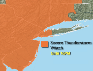
The threat of scattered strong to severe storms will exist into this evening. A Severe Thunderstorm Watch has been posted until 10PM for the entire area excluding Suffolk County and Southeast CT. Please keep an eye to the sky for threatening weather. Damaging winds in excess of 58mph and or one 1″ hail is possible in any severe storm. The showers and storms will wind down later tonight.
A familiar forecast is on the way for Thursday. It will be hot and humid. Scattered afternoon storms are possible but will not be as strong.
Relief from the humidity will arrive on Friday behind a cool front. Skies will be mainly sunny.
The weekend at this time looks decent with plenty of sun, warm readings and tolerable levels of humidity.
Stay Tuned.
Keep it here for a no nonsense, no hype forecast.
Rest of Today:
Hazy, hot and humid. Spotty strong to severe Storms. Readings will be in the 80s and 90s. East to Southeast winds at 5-10mph.
Tonight:
Scattered early storms, otherwise partly cloudy, warm and muggy. Lows in the mid to upper 70s in urban areas, the upper 60s and lower 70s inland. Winds becoming West at under 5mph.
Thursday:
Hazy, hot and humid. Spotty PM Storms. Highs around 90º.
Friday:
Mostly sunny. Less humid. Highs in the upper 80s.
Saturday:
Mostly sunny. Highs in the mid to upper 80s.
Sunday:
Mostly sunny, hot and more humid. Highs around 90º.