Synopsis:
Clouds will give way to sun today as high pressure moves in from the Midwest.
Another round of rain will occur on Wednesday with low pressure over the Ohio Valley moving to the East. Well to the North little if any rain may fall. The heaviest and steadiest rain will fall to the South of the City.
The sun will return Thursday and tranquil conditions are expected through Friday along with slightly above average temperatures.
The weekend will start of with showers as low pressure once again moves in from the West.
Stay Tuned.
Keep it here for a no nonsense, no hype forecast.
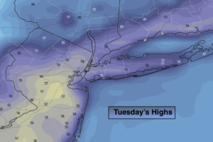
Today:
Clouds to sun. Highs in the mid 50s. North/Northwest winds at 5-10mph.
Tonight:
Increasing clouds. Lows around 40º in the City, the 30s inland. Northeast winds at 5mph.
Wednesday:
Rain likely. Highs around 50º.
Thursday:
Sunny. Milder. Highs in the mid to upper 50s.
Friday:
Sun and clouds. Highs in the upper 50s.
Saturday:
Mostly cloudy with a chance of showers. Highs in the mid 50s.
***Please take “social distancing” seriously during this time. We will get through this.****