Synopsis:
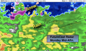
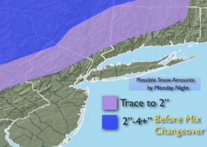
A storm will intensify off the Mid-Atlantic coast today. Periods of rain is expected (could be a bit of wet snow at the onset over the nearby ‘burbs). Well inland, a mix of wet snow and rain is likely. The potential for some accumulation exists, especially over the high elevations and colder surfaces well inland. Potential snow amounts are above. Not a big deal for 90% of the NYC tri-state area. The heaviest rain will fall along the coast.
The rain will taper off this evening as the storm moves North and East.
The sun will return Tuesday as high pressure moves in from the Midwest.
Another round of rain will occur on Wednesday with low pressure over the Ohio Valley moving to the East.
The sun will return Thursday and tranquil conditions are expected through Friday along with slightly above average temperatures.
Stay Tuned.
Keep it here for a no nonsense, no hype forecast.
Today:
Rain. Wet snow North and West will go over to rain. Highs in the lower 40s, 30s inland. East to Northeast winds at 10-20mph.
Tonight:
Rain during the evening, otherwise remaining mostly cloudy. Lows around 40º in the City, the 30s inland. East winds at 8-12mph.
Tuesday:
Mostly sunny. Highs in the mid 50s.
Wednesday:
Rain likely. Highs around 50º.
Thursday:
Mostly sunny. Milder. Highs in the upper 50s.
Friday:
Sun and clouds. Highs in the upper 50s.
***Please take “social distancing” seriously during this time. We will get through this.****