Synopsis:
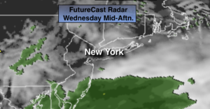
It’ll be a grey Wednesday. A storm will move off the North Carolina coast. This system will be far enough offshore to spare the region a widespread steady rain. Spotty showers are possible mainly to the South of the City. The majority of the region will be dry. The best chance for steadier rain looks to be parts of Ocean County.
The sun will return Thursday and tranquil conditions are expected through Friday along with slightly above average temperatures. A few spotty showers are possible Friday.
The weekend doesn’t look stellar. Saturday looks like the better of the two days. A warm front will be to our South. If the front stays far enough to the South it will be shower free. If it moves farther North it may end up being wet. The best chance for showers will be Sunday with the front and area of low pressure moving through.
Stay Tuned.
Keep it here for a no nonsense, no hype forecast.
Today:
Cloudy. Spotty showers possible from the City and to the South. Much of the time will be dry. Chilly. Highs in the upper 40s. Northeast winds at 10-20mph.
Tonight:
Becoming partly cloudy. Lows in the upper 30s in the City, closer to freezing inland. North winds at 8-12mph.
Thursday:
Sunny. Highs in the mid to upper 50s.
Friday:
Sun and clouds. Spotty showers possible. Highs in the upper 50s.
Saturday:
Mostly cloudy. Spotty showers possible. Highs around 50º.
Sunday:
Showers likely. Highs around 60º.
***Please take “social distancing” seriously during this time. We will get through this.****