Synopsis:
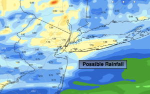
Low pressure moving in from the Ohio Valley will cause rain to develop by late evening and continue into early Thursday morning. The rain could be heavy for a time. Up to an inch is possible in spots. It will be a quick hitter. The rain will taper off by mid morning. Grey skies will rule for the afternoon. It’s Winter’s finale as Spring arrives at 11:50PM EDT.
Much warmer conditions are expected by Friday with readings getting into the 70s with a Southwest wind. It will be much cooler closer to the ocean. A mix of sun and clouds is expected along with spotty showers as a cool front approaches.
Bright and cooler weather will greet us for the weekend due to strong high pressure over the Northeast.
Stay Tuned.
Keep it here for a no nonsense, no hype forecast.
Tonight:
Rain. Becoming heavy at times. Lows in the upper 30s to lower 40s. Southeast to East winds at 5-10mph.
Thursday:
Morning rain, otherwise remaining mostly cloudy. Highs in the lower 50s. Northeast winds at 5mph.
Friday:
Sun and clouds. Balmy. Slight chance of a shower. Highs in the mid 70s. Much cooler over Long Island and Connecticut.
Saturday:
Mostly sunny. Cooler. Highs in the lower 50s.
Sunday:
Sunny. Chilly. Highs in the mid 40s.
Monday:
Mostly cloudy. Showers possible. Cooler. Highs in the mid 40s.
***Please take “social distancing” seriously during this time. We will get through this.****