Synopsis:
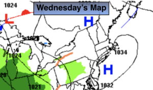
Today will be sunny with high clouds. Readings will be about five degrees above the average high of 50º. High pressure slipping off the coast is responsible for our tranquil last full day of Winter.
Low pressure moving in from the Ohio Valley will cause rain to develop by late evening and continue into Thursday morning. The rain could be heavy for a time. Up to an inch is possible in spots. The rain will taper off by late morning. The arrival of Spring will occur late Thursday night at 11:50PM EDT.
Much warmer conditions are expected by Friday with readings getting into the 70s with a Southwest wind. Showers are possible during the afternoon with an approaching cool front.
Bright and cooler weather will greet us for the weekend.
Stay Tuned.
Keep it here for a no nonsense, no hype forecast.
Wednesday:
Mostly sunny. Highs in the mid 50s. North to Southeast winds at 5-10mph.
Tonight:
Rain. Becoming heavy at times. Lows in the upper 30s to lower 40s. Southeast to East winds at 5-10mph.
Thursday:
Morning rain, otherwise remaining mostly cloudy. Highs in the lower 50s.
Friday:
Sun and clouds. Balmy. Slight chance of a shower. Highs in the lower to mid 70s.
Saturday:
Mostly sunny. Cooler. Highs in the lower 50s.
Sunday:
Sunny. Chilly. Highs in the mid 50s.
***Please take “social distancing” seriously during this time. We will get through this.****