Synopsis:
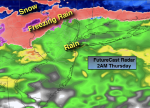
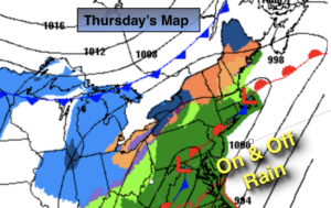
Tonight will be cloudy. A front will stall along the East coast and waves of low pressure ride up the coast. It maybe cold enough as high pressure noses in from Eastern Canada late tonight and Thursday morning for rain to start off as freezing rain or sleet North and West (first map above). All other areas will experience plain rain.
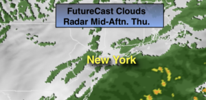
The morning commute will be wet for most areas. There will still be pockets of freezing rain well inland for a time. The rain will taper off during the late morning and much of the midday and afternoon hours should be dry (3rd map above).
On Friday as the second wave of low pressure moves North more rain is likely during the early morning. A break in the rain is likely by mid-morning. As the low intensifies over the region and moves into Southern New England another round of showers is possible on the backside of the storm.
The weekend looks decent for February standards. Saturday will be tranquil and cool under a mix of sun and clouds. A weak area of low pressure will move South of the region Saturday night and Sunday morning. At this time it doesn’t look like a big deal. Flurries are in the forecast Sunday morning, otherwise skies will be partly sunny.
Stay Tuned.
Keep it here for a no nonsense, no hype forecast.
Tonight:
Rain developing toward midnight. Sleet and freezing rain likely inland. Lows in the mid 30s in the City, around freezing inland. Temperatures will rise late. East winds at 5-10mph.
Thursday:
Periods of rain. Sleet and freezing rain possible for a time North and West in the morning.The rain will taper off midday. Spot showers are possible. Highs in the 30s well inland near 50º at the coast.
Friday:
Warmer. Morning rain, possibly heavy, will give way to mostly cloudy skies. Another round of showers is possible later in the afternoon. Highs in the lower 50s.
Saturday:
Partly sunny. Highs around 40º.
Sunday:
Early flurries, otherwise becoming partly sunny. Highs around 40º.
Monday:
Partly sunny, milder. Highs in the upper 40s.