
Synopsis:.
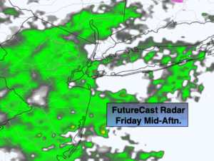
Clouds will dominate today as a low takes shape over the Carolinas. Scattered showers will develop during the morning hours and continue on and off through the day. The steadiest rain will be later in the afternoon just in time for the evening commute.
The storm will hug the coast tonight and Saturday. Rain will become heavy at times. There is no cold air available for this to be snow. On and off rain is expected throughout the day on Saturday as the low moves through our area. The second map above is the rainfall forecast by the NAM model of 1″-3″ of rain by Saturday evening. The heaviest totals will be from the City on East.
Sunday will be the better half of the weekend despite the gusty wind. A mix of clouds and sun is expected.
High pressure will move in for Monday under a mix of sun and clouds.
On Tuesday, another low will form over the Central Appalachians and move over or near the area. A mix of snow, sleet and rain is possible inland. Rain is likely at this time along the coast. This can change either to more frozen or to more liquid precipitation. We’ll fine tune as we get closer.
Stay Tuned.
Keep it here for a no hype, no nonsense forecast.
Today:
Cloudy. Showers will develop by late morning. Steadier rain will occur later in the day. Highs in the mid 40s. East winds at 5-10mph.
Tonight:
Rain, heavy at times. Much milder with temperatures rising through the 40s throughout. East winds at 5-10mph.
Saturday:
On and off rain (heavy early AM Eastern areas ). Mild. Highs in the mid 50s.
Sunday:
Partly sunny, windy. Highs in the mid to upper 40s.
Monday:
Partly sunny. Chilly. Highs around 40º.
Tuesday:
Rain likely along the coast. A mix inland. Highs in the 30s inland, 40s at the coast.