Synopsis:.
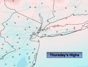
Canadian high pressure will move over the region today. Readings will only be in the lower to mid 30s way below the average high of 44º.
It won’t be as harsh on Friday as clouds dominate with a wind off the Atlantic. Showers will develop during the afternoon.
A storm will ride up the coast Friday night and Saturday. Another round of rain is expected. There is no cold air available for this to be snow. The rain will taper off during the afternoon.
Sunday will be the better half despite the gusty wind. A mix of clouds and sun is expected.
Monday will be tranquil, then all eyes will be on a developing storm over the Southern states.
Stay Tuned.
Keep it here for a no hype, no nonsense forecast.
Today:
Sunny and cold. Highs in the lower to mid 30s. North to Southeast winds less than 5mph.
Tonight:
Increasing clouds. Lows around freezing in the City, the teens to 20s inland. Light Southeast winds.
Friday:
Thickening clouds. Showers are likely by afternoon. Highs in the mid 40s.
Saturday:
Periods of rain, tapering off in the afternoon. Mild. Highs in the mid 50s.
Sunday:
Partly sunny, windy. Highs in the mid 40s.
Monday:
Partly sunny. Chilly. Highs in the lower 40s.