
Synopsis:.
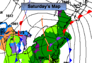
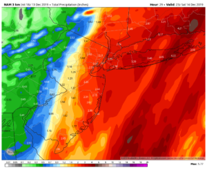
A storm developing over the Piedmont of the Carolinas will move North tonight. Rain will become heavy at times. Temperatures will continue rise as the storm hugs the coast. There is no cold air available for this to be snow with this type of track. The batch of heavy rain will work off the coast early Saturday morning. On and off rain is expected throughout the day as the storm moves over or very close to our region. The second and third maps above are the rainfall forecast by the GFS & NAM models. Both are showing a general of 1″-3″ of rain by Saturday evening. The heaviest totals will be from the City on East. Street and highway flooding is possible along with stream and small river flooding. Please use caution.
Sunday will be the better half of the weekend despite the gusty wind. A mix of clouds and sun is expected.
The models have sped up the timing of the next weather event for early next week. It now looks like an arc of moisture will stream ahead of a developing low in the Tennessee Valley. This change will result in the potential for snow to break out Monday afternoon for most areas. South of the City a mix of snow, sleet and rain is likely. There is just enough cold air for a possible accumulation of snow by Monday Night. The best chance of this is North and West of the City. The warm air should win the battle and the frozen precipitation will go over to rain along the coast Monday night. Inland mixed precipitation will continue.
The low will move off the coast on Tuesday. Any precipitation will end in the morning.
Wednesday we’ll dry out under a mix of clouds and sun. It will turn dramatically colder during the afternoon as Arctic air moves in .
Stay Tuned.
Keep it here for a no hype, no nonsense forecast.
Tonight:
Rain, heavy at times. Much milder with temperatures rising through the 40s and into the 50s South and East of the City. East winds at 8-12mph.
Saturday:
On and off rain. Mild. Highs in the mid 50s.
Sunday:
Partly sunny, windy. Highs in the mid to upper 40s.
Monday:
Cloudy and cold with snow developing during the afternoon. A mix of snow, sleet and rain to the South of the City. Highs in the mid to upper 30s.
Tuesday:
Rain along the coast. Sleet and freezing rain inland during the morning. Remaining mostly cloudy during the afternoon. Highs in the 40s along the coast, the upper 30s inland.
Wednesday:
Partly sunny, windy and turning colder during the afternoon. Highs around 40º in the morning with readings dropping to near freezing by late day.