Synopsis:.
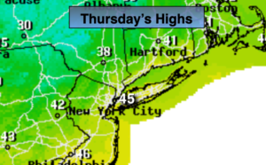
The jet stream, that river of air that guides our weather systems, is moving Southeast out of Canada. This flow will keep our temperatures several degrees below the average highs of the upper 40s through Saturday.
More sun will greet us today. It’ll be breezy and cool.
A cool front will work toward the area on Friday. Sun will give way to clouds with late day flurries or sprinkles possible.
The weekend will be bright as high pressure works in. Saturday will only be in the 30s. Readings will rebound on Sunday.
Much milder readings are expected on Monday along with the chance of showers.
No major storms are on the horizon.
Stay Tuned.
Keep it here for a no hype, no nonsense forecast.
Today:
Partly sunny and breezy. Highs in the mid 40s. West winds at 15-2m5ph.
Tonight:
Partly cloudy. Lows in the lower to mid 30s in the City, the 20s inland. West winds diminishing to 5-10mph.
Friday:
Sun and clouds. Scattered flurries or sprinkles. Highs in the lower to mid 40s.
Saturday:
Sunny and cold. Highs in the mid to upper 30s.
Sunday:
Sunny. Not as harsh. Highs in the mid 40s.
Monday:
Mostly cloudy with showers. Much milder. Highs in the mid 50s.