Synopsis:
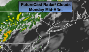
A front will work in from the west slowly today. Scattered showers are possible just about any time, but the best chance will be later in the day. It’ll be warm. The sun may shine from time to time. A period of rain is likely tonight with the passage of the front.
High pressure will work in from Southeastern Canada on Tuesday. Any morning clouds and coastal showers will give way to some sun. Seasonal temperatures are expected.
A low in the Western Atlantic has to be monitored for mid to late week. The models are all over the place with its placement and track. If the storm’s rain shield moves far enough West showers or a period of rain is likely Wednesday through Friday. This is no way etched in stone, but the potential is there. It could very well be dry with plenty of sun. The uncertainly continues. Check back with JMW for the very latest.
Stay Tuned.
Keep it here for a no nonsense, no hype forecast.
Today:
Mostly cloudy with scattered showers, best chance is later in the day and at night. Warm. Highs in the mid 70s. Southwest winds at 10-20mph.
Tonight:
Periods of rain. Cooler and less humid. Lows in the mid 50s in the City, the upper 40s inland. North winds at 8-12mph.
Tuesday:
Clouds to sun. Highs in the upper 60s.
Wednesday:
Mostly cloudy. Potential for showers or a period of rain. Highs in the mid 60s.
Thursday:
Mostly cloudy. Potential for showers or a period of rain. Highs in the mid 60s.
Friday:
Mostly cloudy. Potential for showers or a period of rain. Highs in the mid 60s.