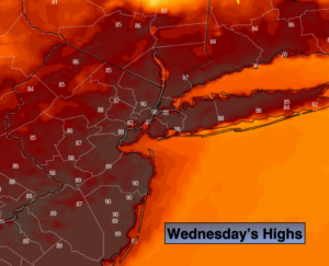
Synopsis:
August-like conditions will be with us today as a bubble of hot air works in from the South and West around the area of offshore high pressure. Highs Wednesday will be well into the 80s to near 90º in some spots. A spotty afternoon storm can’t be ruled out.
A season changer front will arrive tonight and Thursday. A dramatic drop in temperature is expected. Temperatures will be almost thirty degrees colder than Wednesday. There will be areas of light rain with a front stalling just South of the region tonight and Thursday. Below average readings will stick around through Saturday. Fall conditions will finally greet us for more than just a day. The average high is 69º.
Stay Tuned.
Keep it here for a no nonsense, no hype forecast.
Today:
Mostly sunny, hot and humid. Spotty late day storms are possible. Highs in the upper 80s to near 90º. West Winds becoming Northwest later in the day at 8-12mph with gusts to 20mph.
Tonight:
On and off light rain devleoping. Much cooler and less humid. Lows in the lower to mid 50s in the City, the 40s and 50s inland. Northeast winds at 10-15mph.
Thursday:
Cloudy with on and off rain. Much cooler. Highs only in the 50s to around 60º.
Friday:
Partly sunny, cooler and breezy. Highs in the mid 60s.
Saturday:
Sunny and cool. Highs in the lower to mid 60s.
Sunday:
Partly sunny and seasonal. Highs in the upper 60s.