CBS2 This Morning. Are you for or against the dramatic drop in temperature?

Synopsis:
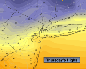
A drastic temperature swing has occurred. Record high temperatures, in the 90s occurred on Wednesday. Some regions recorded the highest temperature for the month of October! A significant front, to say the least, has moved through the region. Temperatures will be almost thirty to forty degrees colder today than yesterday. A shock to the body as you step outdoors.
There will be areas of rain (which we desperately need) with the front stalling just South of the region today.
Friday and Saturday will be mainly sunny with a nip in the air. Readings will below the average high of 69º. High pressure over Eastern Canada and the Northeast will supply the cooler air.
Sunday will be milder as the high slips offshore and a Southwesterly flow develops.
Stay Tuned.
Keep it here for a no nonsense, no hype forecast.
Today:
Cloudy with on and off rain. Much cooler. Highs only in the 50s to around 60º. Northeast to East winds at 5-10mph.
Tonight:
Spotty light rain. Cool. Lows in the lower to mid 50s in the City, the 40s and 50s inland. Northeast winds at 5-10mph.
Friday:
Partly sunny, cool and windy. Highs in the mid 60s.
Saturday:
Sunny and cool. Highs in the lower to mid 60s.
Sunday:
Partly sunny and seasonal. Highs near 70º.
Monday:
Mostly cloudy with scattered showers. Highs in the lower to mid 70s.