Synopsis:
High pressure will be in control through midweek. This will result in a mix of sun and clouds and cooler temperatures today- Rosh Hashanah. A few light scattered showers are possible West of the City today. It’ll be a refreshing change from 80º temperatures of the weekend. This change is due to a Northeast wind off the cooler Atlantic.
Summer-like weather will make a comeback midweek as high pressure slips off the coast and a Southwesterly wind materializes. Highs by Wednesday will be well into the 80s to near 90º in some spots.
A season changer front will arrive by late week-meaning Fall conditions will finally greet us. Showers are likely on Thursday with a front stalling over the region; it will be significantly cooler. Below average readings will stick around through Friday. Once the front pushes offshore, the morning showers will give way to sun.
Stay Tuned.
Keep it here for a no nonsense, no hype forecast.
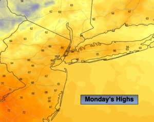
Today:
Clouds and sun, cooler. A few light spotty showers are possible West of the City. Highs in the upper 60s. Northeast to Southeast winds at 5-10mph.
Tonight:
Mostly cloudy. Lows near 60º in the City, the 50s inland. Southeast to South winds at 5mph.
Tuesday:
Partly sunny, warmer. Highs in the mid to upper 70s.
Wednesday:
Mostly sunny, hot and humid. Highs in the upper 80s to near 90º.
Thursday:
Mostly cloudy with showers. Much cooler. Highs in the upper 60s.
Friday:
Morning showers will give way to some sun. Cooler and breezy. Highs in the mid 60s.