Synopsis:
High pressure will be in control through midweek. This will result in mainly sunny skies and near to above average temperatures through Wednesday. Average highs are around 70º.
Rosh Hashanah is tomorrow. It will be seasonal with a cooler flow off the Atlantic. Summer-like weather will make a comeback midweek as high pressure slips off the coast and a Southwesterly wind materializes. Highs by Wednesday will be well into the 80s to near 90º in some spots.
A season changer front will arrive by late week-meaning Fall conditions will finally greet us. Showers are likely on Thursday with a front stalling over the region; it will be significantly cooler.
Stay Tuned.
Keep it here for a no nonsense, no hype forecast.
Today:
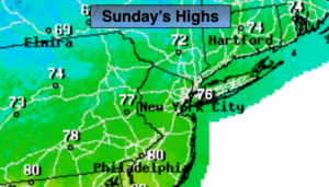
Sunny, not as warm and much less humid. Highs in the mid to upper 70s. Northeast winds at 8-12mph.
Tonight:
Clear and cooler then recent nights around 60º in the City, the 40s and 50s inland. Northeast winds at 5-10mph.
Monday:
Sunny, cooler. Highs in the lower 70s.
Tuesday:
Sunny, warmer. Highs around 80º.
Wednesday:
Mostly sunny, hot and humid. Highs in the upper 80s to near 90º.
Thursday:
Mostly cloudy with showers. Much cooler. Highs only near 70º.