Synopsis:
High pressure will be in control this weekend into midweek. This will result in mainly sunny skies and above average temperatures through Sunday. Average highs are in the lower 70s. A weak front will move through tonight with a few scattered showers.
Rosh Hashanah is Monday. It will be seasonal with a cooler flow off the Atlantic. Summer will make a comeback midweek as high pressure slips off the coast and a Southwesterly wind materializes.
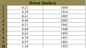
This September may make the 10 top list of driest September’s on record. The top ten driest September’s are above (records go back to 1869). So far to date this month, Central Park has recorded a mere 0.95″ of rainfall in the bucket-the average for the month is 4.28″. If we keep it dry until Midnight Monday night this will be the 8th driest September on record.
Stay Tuned.
Keep it here for a no nonsense, no hype forecast.
Today:
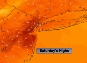
Mostly sunny, warm. Highs around 80º. Southwest winds at 8-12mph.
Tonight:
Partly cloudy a few showers are possible. Lows in the lower to mid 60s throughout. Southwest to North winds at 5-10mph.
Sunday:
Mostly sunny. Highs in the upper 70s.
Monday:
Sunny, cooler. Highs in the lower 70s.
Tuesday:
Sunny, warmer. Highs around 80º.
Wednesday:
Mostly sunny and hot and humid. Highs in the upper 80s to near 90º.