Synopsis:
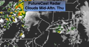
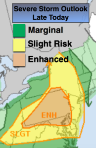
Two rounds of showers and storms are in the forecast for today. The first batch will be in the morning with the warm front. The second round will be later in the afternoon and evening with a cool front. In between-the sun will shine for a time (1st map above). Some of the thunderstorms later in the day maybe severe, especially West of the City (2nd map). The showers and storms will end early tonight.
The weather looks to cooperate for getaway day Friday and into the Memorial Day Holiday Weekend. No major systems look to affect the region through Monday. High pressure will be nearby. Temperatures will be above average but nothing too hot. This time around; I am well liked!
Keep it here for a no nonsense, no hype forecast.
Stay tuned.
Today:
Spotty showers in the morning, then becoming partly sunny. Late day and evening showers and storms are likely. Some of the storms maybe severe. Highs in the lower to mid 70s. South winds at 10-15mph.
Tonight:
Scattered early showers or storms. Some of the storms maybe severe. Lows around 60º in the City, the 50s inland. Southwest to Northwest winds at 10-20mph.
Friday:
Partly sunny. Highs in the mid 70s.
Saturday:
Mostly sunny. Highs in the mid 70s.
Sunday:
Partly sunny. Warmer. Highs in the lower 80s.
Memorial Day:
Mostly sunny. Warm. Highs around 80º.