Synopsis:
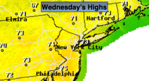
Our delightful conditions will continue through today as high pressure dominates along the East coast. Today will be a gem with abundant sunshine and seasonal temperatures (average highs are in the lower 70s).
A system will move in from the West Thursday with a chance of two rounds of showers and storms. The first batch will be in the morning. The second round will be later in the afternoon and evening. In between-the sun will shine for a time. Some of the thunderstorms later in the day Thursday maybe severe.
The weather looks to cooperate for the end of the week and into the Memorial Day Holiday Weekend. No major systems look to affect the region through Monday. High pressure will be nearby. Temperatures will be above average but nothing too hot.
Keep it here for a no nonsense, no hype forecast.
Stay tuned.
Today:
Sunny. Highs in the lower 70s. North to South winds at 5-10mph.
Tonight:
Becoming mostly cloudy. Chance of showers late. Lows in the upper 50s in the City, near 50º inland. Light South wind.
Thursday:
Spotty showers in the morning, then becoming partly sunny. Late and evening showers and storms are possible. Some of the storms maybe severe. Highs in the lower 70s.
Friday:
Partly sunny. Highs in the mid 70s.
Saturday:
Partly sunny. Highs in the mid 70s.
Sunday:
Partly sunny. Warmer. Highs around 80º.