Synopsis:
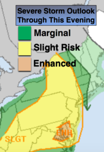
A couple of chances of scattered showers and possible strong to severe storms are likely later this afternoon into early tonight. A mix of sun and clouds is expected into this evening. Some of the thunderstorms maybe severe (map above). The showers and storms threat will end around midnight .
The weather looks to cooperate for getaway day Friday and into the Memorial Day Holiday Weekend. No major systems look to affect the region through Monday. High pressure will be nearby. Temperatures will be above average but nothing too hot. This time around; I am well liked!
Keep it here for a no nonsense, no hype forecast.
Stay tuned.
Rest of Today Into This Evening:
A mix of sun and clouds. A couple of rounds of showers and scattered thunderstorms. Some of the storms maybe severe. South winds at 10-15mph.
Tonight:
Scattered showers or storms. Some of the storms maybe severe. The activity will end around midnight. Lows around 60º in the City, the mid to upper 50s inland. Southwest to Northwest winds at 10-20mph.
Friday:
Partly sunny and breezy. Highs in the mid 70s. Northwest winds at 15-25mph.
Saturday:
Mostly sunny. Highs in the mid 70s.
Sunday:
Partly sunny. Warmer. Highs in the lower to mid 80s.
Memorial Day:
Mostly sunny. Highs around 80º.
Tuesday:
Mostly sunny. Highs around 80º.