Synopsis:
The last batch of showers with the upper low over the Northeast will swing through this evening. After midnight skies will become partly cloudy. It’ll be chilly.
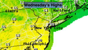
We’ll finally dry out Wednesday as high pressure moves from the Southern Appalachians to Eastern North Carolina. Readings will be a few degrees below the average high of 70º.
Morning showers are possible Thursday otherwise skies will become partly sunny. Friday is looking decent, although a spot shower can’t be ruled out during the afternoon.
The weekend is shaping up to be dry with a mix of sun and clouds as high pressure begins to build along the East coast. Temperatures should be a few degrees above average. Finally some comfortable temperatures!
Keep it here for a no nonsense, no hype forecast.
Stay tuned.
Tonight:
Scattered showers early, otherwise mostly cloudy. Cold. Lows in the lower to mid 40s. Northwest winds at 8-12mph.
Wednesday:
Partly sunny. Highs in the mid 60s. Northwest winds at 5-10mph.
Thursday:
Scattered morning showers, otherwise becoming partly sunny. Highs in the upper 60s.
Friday:
Partly sunny. A spot afternoon shower is possible. Highs around 70º.
Saturday:
Partly sunny. Warmer. Highs in the mid 70s.
Sunday:
Partly sunny. Highs in the mid 70s.