Synopsis:
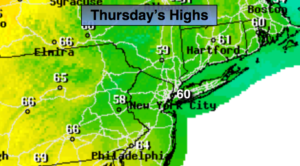
High pressure will move to Eastern New England Thursday. This will result in an Easterly flow off the colder Atlantic. Temperatures will be several degrees below average high (the average high is 69º). The clouds will win the battle.
A few spotty showers are possible tonight as moisture works up from the South and East.
On Friday, a warm front will move North through most of the region. Showers are expected but there should be some times of sun. If we get enough sun readings could pop into the 70s. Readings North and East of the City will be much cooler.
Taking a peek at Mother’s Day Weekend. Saturday will be the better half of the weekend with mainly sunny skies. Unfortunately, Mother’s Day looks to be wet. Low pressure will move up from the Southern Appalachians. Rain is likely. Only computer model want to make mom happy-the GFS. This outlier has it partly sunny for Sunday. One can only hope, but I have to go with the consensus at this time, meaning a wet day.
Stay tuned.
Keep it here for a no nonsense, no hype forecast.
Today:
Mainly cloudy. Cool. Highs in the upper 50s to around 60º. East winds at 8-15mph.
Tonight:
Mostly cloudy. Lows around 50º in the City, the upper 40s inland. East winds at 5mph.
Friday:
Mostly cloudy with a chance of showers. Warmer. Highs in the lower to mid 70s. Cooler North and East of the City.
Saturday:
Mostly sunny and seasonal. Highs around 70º.
Mother’s Day:
Rain likely. Highs around 60º.
Monday:
Mostly cloudy with scattered showers. Highs in the lower 60s.