Synopsis:
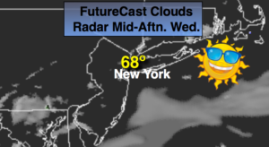
High pressure will work in from Eastern Canada today and Thursday. This will result in an Easterly flow off the colder Atlantic. Temperatures will be near average today and several degrees below average tomorrow (the average high is 69º). A mix of sun and clouds is expected today with clouds dominating tomorrow .
By Friday, a warm front will work North and through our area. Showers are expected but there should be some times of sun. If we get enough sun readings could pop into the 70s.
Taking a peek at Mother’s Day Weekend. Saturday will be the better half of the weekend with mainly sunny skies. Unfortunately, Mother’s Day looks to be wet. Low pressure will move up from the Southern Appalachians. Rain is likely.
Stay tuned.
Keep it here for a no nonsense, no hype forecast.
Today:
Sun and clouds. More seasonal. Highs in the upper 60s. Northeast winds at 8-12mph.
Tonight:
Mostly cloudy. Lows around 50º in the City, the upper 40s inland. East winds at 5mph.
Thursday:
Clouds, some sun. Cool. Highs around 60º.
Friday:
Mostly cloudy with a chance of showers. Warmer. Highs in the lower to mid 70s.
Saturday:
Mostly sunny and seasonal. Highs around 70º.
Mother’s Day:
Rain likely. Highs around 60º.