Synopsis:
High pressure along the Eastern Seaboard will dominate our weather through today. It’ll be a bright day with readings at least 5 degrees above average. The average high is 68º. A cool front will move through during the evening with scattered showers and possibly a thunderstorm.
High pressure will work in from Eastern Canada midweek. this will result in an Easterly flow off the colder Atlantic Wednesday and Thursday. Temperatures will be several degrees below average. Moisture will work in off the ocean causing more clouds than sun. Spotty showers can’t be ruled out on Thursday.
By Friday, a warm front will work North and through our area. Showers are expected but there should be some times of sun. If we get enough sun readings could pop into the 70s.
Taking a peek at Mother’s Day Weekend. Saturday should be dry, unfortunately on Mother’s Day the threat of showers exist. Still plenty of time to work on that forecast.
Stay tuned.
Keep it here for a no nonsense, no hype forecast.
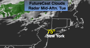
Today:
Partly sunny. Warm. Chance of late day showers and isolated thunderstorms. Highs in the mid 70s. South winds at 8-12mph.
Tonight:
An evening shower or storm otherwise, becoming partly cloudy. Lows in the mid 50s in the City, the upper 40s inland. North winds at 5mph.
Wednesday:
Clouds and sun. Cooler. Highs in the mid 60s.
Thursday:
Clouds, some sun. A stray shower is possible. Cool. Highs around 60º.
Friday:
Mostly cloudy with a chance of showers. Warmer. Highs in the mid 70s.
Saturday:
Partly sunny and seasonal. Highs around 70º.