Synopsis:
A warm front will be working up from the South today resulting in waves of rain-meaning it won’t be raining all of the time. The warm front should clear areas to the South and West of the City. These areas could pop to near 70º. Where the warm front does not pass it will be much cooler with readings in the upper 50s and 60s.
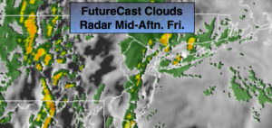
A cool front will move through the region this evening. A line of showers and thunderstorms will accompany the front. Some of the rain maybe torrential and a few isolated storms maybe severe, especially to the South and West of the City.
The rain will end from West to East later this evening. Skies will clear and it will become windy.
The storm will intensify over New England on Saturday. This will cause strong winds and chilly readings. A mix of sun and clouds is expected. Wind gusts of 35-40mph will be common. The winds will diminish later in the day.
On Sunday, weak low pressure will work toward the Northeast from the Ohio Valley. Any sun will give way to clouds. Scattered afternoon showers are possible. It won’t be a washout.
Stay tuned.
Keep it here for a no nonsense, no hype forecast.
Today:
On and off rain. Highs in the upper 50s and lower 60s near the City and over Long Island and Connecticut. Readings will be in the 60s to near 70º to the South and West through parts of NJ. A band of showers and storms will work in later in the day. East to Southeast winds increasing to 10-20mph.
Tonight:
Rain and storms will end this evening from West to East. Becoming windy. Lows around 50º in the City, the 40s elsewhere. West winds increasing to 15-30mph with higher gusts.
Saturday:
Partly sunny, windy and chilly. Highs in the upper 50s.
Sunday:
Sun to clouds. Scattered afternoon showers. Highs around 60º.
Monday:
Mostly sunny. Highs in the mid 60s.
Tuesday:
Morning showers, afternoon sun. Warmer. Highs in the mid 60s to around 70º.