Synopsis:
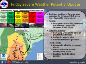
***TORNADO WATCH FOR MERCER & OCEAN COUNTIES IN NJ UNTIL 9PM***A cool front will move through the region this evening. A line of showers and thunderstorms will accompany the front. Some of the rain maybe torrential and a few isolated storms maybe severe, especially to the South and West of the City. An isolated tornado is possible within the watch area . First map above has extreme Western areas of NJ in a slight risk of severe thunderstorms.
The rain will end from West to East later this evening. Skies will clear and it will become windy.
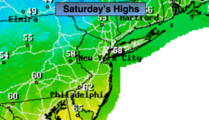
The storm will intensify over New England on Saturday. This will cause strong winds and chilly readings. A mix of sun and clouds is expected. Wind gusts of 35-40mph will be common. The winds will diminish later in the day.
On Sunday, weak low pressure will work toward the Northeast from the Ohio Valley. Any sun will give way to clouds. Scattered showers are possible from late morning into mid-afternoon. It won’t be a washout.
Monday will be mostly sunny and cool. A quick moving system will give us a shot of rain Monday night. Cool temperatures are expected through midweek.
Stay tuned.
Keep it here for a no nonsense, no hype forecast.
Tonight:
Rain and storms (some storms will be strong to isolated severe) this evening. The rain will end from West to East. Clearing and becoming windy. Lows around 50º in the City, the 40s elsewhere. West winds increasing to 15-30mph with higher gusts.
Saturday:
Partly sunny, windy and chilly. Highs in the upper 50s. West winds at 15-30mph with gusts to 40mph.
Sunday:
Sun to clouds. Scattered showers. Highs in the upper 50s.
Monday:
Mostly sunny. Highs around 60º.
Tuesday:
Morning showers, afternoon sun. Warmer. Highs in the mid 60s.
Wednesday:
Clouds and sun. Highs in the lower 60s.