Synopsis:
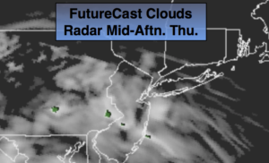
A weak disturbance will move into the region today. Any morning sun will give way to clouds. Stray afternoon showers cannot be ruled about. Many areas will remain dry (FutureCast clouds and radar above). Areas of drizzle and light rain will develop later tonight as a warm front approaches.
On Friday, a cool front will move toward the region. On and off showers are likely. There will be dry times. A storm will form on the front over the area and keep rain in the forecast early Friday night.
The storm will intensify over New England on Saturday. This will cause strong winds and chilly readings. A mix of sun and clouds is expected.
On Sunday weak low pressure will work toward the Northeast from the Ohio Valley. Any sun will give way to clouds. Spotty afternoon showers are possible. It won’t be a washout.
Stay tuned.
Keep it here for a no nonsense, no hype forecast.
Today:
Any morning sun will give way to increasing clouds. Areas to the North will have the sunshine the longest today. A stray afternoon shower is possible. Highs in the lower to mid 60s. South winds at 5-10mph.
Tonight:
Cloudy with areas of light rain and drizzle. Lows in the lower 50s. Southeast to East winds at 5-10mph.
Friday:
Cloudy. On and off showers. Highs in the mid 60s.
Saturday:
Partly sunny, windy and chilly. Highs in the upper 50s.
Sunday:
Sun to clouds. Slight chance of late day showers. Highs in the mid 60s.
Monday:
Mostly sunny. Highs in the mid 60s.