Synopsis:
Today will start off with sun as high pressure dominates over the Mid-Atlantic. A quick moving disturbance will head our way from the Northwest later in the day with increasing clouds. Scattered showers are expected later this evening and tonight.
Another high will slip off the New England for Wednesday bring with it plenty of sunshine and seasonal temperatures. A warm from will move toward the region on Thursday bringing with it the possibility of some showers or patchy drizzle. On Friday cool front will be approaching from the West. Balmy conditions and scattered showers are expected.
The Holiday Weekend looks unsettled with times of showers, but there will also be some sun.
Keep it here for a no nonsense, no hype forecast.
Stay tuned.
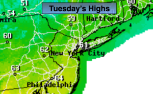
Today:
Sun to afternoon clouds. Highs in the lower 60s. West to Northwest winds at 15-25mph.
Tonight:
Cloudy with areas of light rain. Lows in the mid 40s in the City, the 30s inland. Northwest to North winds diminishing to 5mph.
Wednesday:
Becoming mostly sunny. Highs around 60º.
Thursday:
Mostly cloudy. Spotty showers possible. Highs around 60º.
Friday:
Mostly cloudy and warm. Showers possible by afternoon. Highs near 70º.
Saturday:
Morning rain, some afternoon sun. Highs in the mid 60s.