Synopsis:
A minor system bypassing us to the South this evening. Scattered areas flurries or snow showers are possible over parts of Central and Southern NJ. This won’t be a big deal. Skies will be partly cloudy.
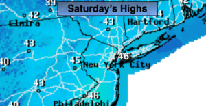
Saturday will feel much better as readings rise into the seasonal mid 40s under mostly sunny skies. High pressure moving off the Northeast coast will be responsible for our delightful day.
On Sunday a storm will track well to our West (warm scenario). Rain is likely along with mild temperatures. The rain looks to taper off by midday. Some late day sun is possible, especially now that the sun will set after 6:30pm!
Tranquil conditions are expected to the beginning of the workweek. Readings will be mild on Monday with temperatures dropping back to more seasonal readings for mid March.
Don’t forget we “Spring Ahead” this weekend. The clocks turn ahead one hour at 2am Sunday morning as Daylight Saving Time begins. We lose an hour of sleep but gain an hour of daylight on the back end. It’s also a good time to change the batteries in your smoke and carbon monoxide detectors.
Keep it here for a no nonsense, no hype forecast.
Tonight:
Mostly cloudy. Not as cold as recent night. A few flurries or snow shower are possible over Southern sections. Lows around freezing in the City, the teens and 20s inland. Southwest to Northwest winds less than 5mph.
Saturday:
Mostly sunny, seasonal. Highs in the mid 40s. North to Southeast winds at 5mph.
Sunday:
Morning Rain. Some late day sun is possible. Highs in the mid to upper 40s.
Monday:
Partly sunny. Mild. Highs around 50º.
Tuesday:
Partly sunny, cooler. Highs in the lower 40s.
Wednesday:
Sunny. Highs in the mid 40s.