Synopsis:
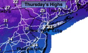
High pressure will move over the Northeast today. The flow will be out of Canada; it’ll be unseasonably cold. Temperatures rise to near freezing. The average high for March 7th is 46º. A mix of sun and clouds is expected. Scattered flurries can’t be ruled as a weak disturbance rotates through from the Northwest.
High pressure will slip off the coast Friday. Any morning sun will give way to thickening clouds. There will be a minor system bypassing us to the South late Friday. Scattered areas of light snow or snow showers will move in during the afternoon. This shouldn’t add up to much.
Saturday will feel much better as readings rise into the 40s.
By Sunday a storm will track well to our West (warm scenario). Rain is likely along with mild temperatures.
Keep it here for a no nonsense, no hype forecast.
Today:
Partly sunny, cold. Scattered afternoon flurries possible. Highs around freezing. West winds at 10-15mph.
Tonight:
Mostly clear and cold. Lows in the mid 20s in the City, the teens and upper single digits inland. Northwest winds at 5mph.
Friday:
Mostly cloudy, not as cold. Late day snow showers are possible. Highs in the mid 30s.
Saturday:
Partly sunny, seasonal. Highs in the mid 40s.
Sunday:
Rain likely. Mild. Highs around 50º.
Monday:
Partly sunny. Mild. Highs in the upper 40s.