
Synopsis:
March will continue to roar. The system that gave parts of the area an accumulating snow early this morning will move off the coast. A dusting to almost 5″ of snow fell in spots while to the South of NYC and along the South shore of Long Island mainly rain fell. The rest of the day will feature mainly cloudy skies.
A ridge of high pressure will nose in from the Great Lakes. Skies may become partly cloudy tonight.
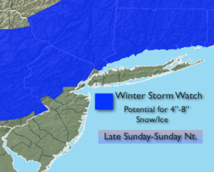
Sunday may start off with a glimpse of sun, but clouds will increase and thicken during the day. A storm will track up from the South (system 2). Light rain will develop during the afternoon along the coast. North and West it’ll be snow or a mix. All of the latest computer guidance has the storm track farther to the South and slightly weaker. This is a colder solution. Even the European caved to the other models with an offshore track. The track of the storm looks to run now from Norfolk VA to just Southeast of Cape Cod. This is a classic track for heavy snow for the area. Two elements that will most likely not result in a significant snow for the entire area are: Arctic high pressure is not present to the North (resulting in mixing at the coast for a time) and two-the speed of the storm. It’ll be progressive, meaning it’ll move quickly. A shot of moderate to heavy precipitation is expected for 6 hours Sunday night. The million dollar question is where will the rain, snow line setup? Due to the new development of the track, the rain snow line will be farther to the South and East. Mainly snow is expected from the I-95 corridor and to the North and West with a mix to the Southeast of there. The storm will move be out of here by sunrise Monday. Winter Storm Watches are up for all areas just North and West of the City for the potential of significant snow. The City and coast will have an accumulating snow but amounts will be lower. This is not etched in stone and please continue to check back to JMW for the latest updates.
It’ll be quite cold for the beginning of the workweek under a mix of sun and clouds.
Keep it here for a no nonsense, no hype forecast.
Today:
Early morning snow, mix or rain. Remaining cloudy. Highs around 40º. North to West winds at 5mph.
Tonight:
Partly cloudy. Lows around freezing in the city, the upper 20s inland. West to Northwest winds at 5mph.
Sunday:
Partial early morning sunshine, otherwise thickening clouds with light rain, mix or snow developing during the afternoon. Highs in the lower 40s. At this time, a mix to snow is likely at the coast at night. Mainly snow is expected just inland. Significant accumulations are possible where the precipitation stays mostly snow.
Monday:
Party sunny, wind and cold. Highs in the mid 30s.
Tuesday:
Partly sunny, breezy and cold. Highs around 30º.
Wednesday:
Partly sunny, very cold. Highs in the mid to upper 20s.