Synopsis:
The Spring preview will continue as we head into the first week of February. Readings will feel like late March and April as high pressure moves off the coast. This will result in a warm flow of air. Many will be smiling about this!
A stationary front will be draped from the Mid-Atlantic to the Ohio Valley mid to late week. Arctic high pressure will be over Eastern Canada. The cold air will not make it to our area as the Southerly flow aloft will dominate. Whatever precipitation falls Thursday and Friday will be rain and not snow. By Friday, ahead of a cold front, the temperature has a chance of hitting 60º.
You know where to find a no hype, no nonsense forecast.
Stay tuned.
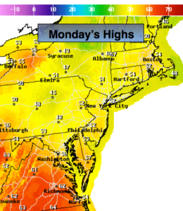
Today:
Partly sunny and mild. Highs in the lower to mid 50s. South wind at 5mph.
Tonight:
Partly cloudy and mild. Lows in the lower 40s in the City, the 30s inland. South winds under 5mph.
Tuesday:
Clouds and sun. April-like. Highs in the mid to upper 50s.
Wednesday:
Partly sunny, cooler. Highs in the mid 40s.
Thursday:
Mostly cloudy. Scattered showers. Highs in the lower to mid 40s.
Friday:
Mostly cloudy. Balmy. Scattered showers. Highs near 60º.