Synopsis:
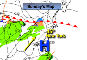
High pressure will settle over coastal Virginia today. This high did not originate at the North Pole, meaning much milder temperatures are on the way. Readings will pop into the 40s on a light Southwest wind.
The thaw continues as we head into the first week of February. Readings will feel like Spring Monday and Tuesday as high pressure moves off the coast and continues with a warm flow of air. Many will be smiling about this!
A stationary front will be draped from the Mid-Atlantic to the Ohio Valley mid to late week. Arctic high pressure will be over Eastern Canada. The cold air will not make it to our area as the Southerly flow aloft will dominate. The warmer air will win the battle. Whatever precipitation fall Thursday and Friday will be rain and not snow.
You know where to find a no hype, no nonsense forecast.
Stay tuned.
Today:
Sunny and mild. Highs in the mid 40s. Southwest winds at 5mph.
Tonight:
Partly cloudy. Lows in the mid 30s in the City, the upper 20s inland. Southwest winds at 5mph.
Monday:
Partly sunny and mild. Highs near 50º.
Tuesday:
Clouds and sun. Spring-like. Highs in the mid 50s.
Wednesday:
Partly sunny, cooler. Highs in the mid 40s.
Thursday:
Mostly cloudy. Scattered showers. Highs in the lower to mid 40s.