Synopsis:
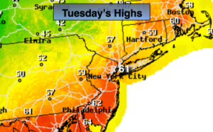
Our Spring preview will continue through today. Readings will feel like April as high pressure moves off the coast and pumps up a warm flow of air. Temperatures will once again flirt with 60º.
A cool front will move through tonight night uneventful. The only change will be the cooler readings expected for Wednesday. Sun will give way to clouds with rain moving in by evening tomorrow.
A stationary front will be draped from the Mid-Atlantic to the Ohio Valley late week. There will be two rounds of rain: one Wednesday night and Thursday morning the other round with a cold front approaching Friday. Ahead of a cold front on Friday temperatures will once again be near 60º.
A return to more seasonal February conditions are expected this weekend. Highs will be near the average high of 38º under a mix of sun and clouds.
You know where to find a no hype, no nonsense forecast.
Stay tuned.
Today:
Clouds and sun. April-like. Highs around 60º. Southwest to Northwest winds at 5-1omph.
Tonight:
Partly cloudy. Colder. Lows in the lower to mid 30s in the City, the 20s inland. Northwest to North winds at 5-10mph.
Wednesday:
Sun to clouds. Rain will move in by evening. Highs in the mid 40s.
Thursday:
Morning rain. Highs in the lower to mid 40s.
Friday:
Mostly cloudy. Balmy. Scattered showers. Highs near 60º.
Saturday:
Mostly sunny and colder. Highs in the mid 30s.