Synopsis:
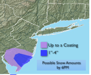
An ocean low well East of North Carolina with an inverted trough swinging back to the coast was responsible for a small area of snow mixed with some rain over Southern NJ. A few inches of snow may accumulate in the heaviest snow band by the time it ends by sunset. All other regions will remain dry.
A Northwest flow will continue as a large high moves from the central portion of the nation to the East coast. This will result in colds readings though the weekend.
The sun will once again dominate through the end of the week and into the weekend. Another cold front will move through on Friday. This will reinforce the cold air through the weekend.
By Sunday, all eyes will be on a Southern storm. It continues to look like a Southern slider, meaning no snow for the area. Any change in the track to the North will result in a period of snow for a part of the region. This seems highly unlikely. JMW is monitoring the situation.
You know where to find a no hype, no nonsense forecast.
Stay tuned.
Tonight:
Any snow or mix over Southern NJ will end by sunset. Clearing skies. Cold. Lows in the upper 20s in the City, the teens and 20s inland. Northwest winds at 5-10mph.
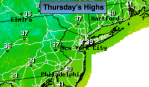
Thursday:
Partly sunny and cold. Highs in the upper 30s. West winds at 10-15mph.
Friday:
Mostly sunny and cold. Highs in the upper 30s.
Saturday:
Sunny and cold. Highs in the mid 30s.
Sunday:
Mostly sunny and cold. Highs in the mid 30s.
Monday:
Party sunny and cold. Highs near 40º.
Keep it here for a no nonsense, no hype forecast.