Synopsis:
High pressure will slip offshore today. Sun will give way to a mix of sun and clouds this afternoon. Readings will be well below the average high of 48º. A cold front will move through tonight with isolated snow showers.
Another high will move in from the Great Lakes Frida and into the weekend. This will reinforce the cold air over the region. The sun will dominate.
All eyes will be on a two Southern storms during the Sunday through Tuesday time frame. They continue to look like Southern sliders (stop thinking food), meaning no snow for the area.
You know where to find a no hype, no nonsense forecast.
Stay tuned.
Today:
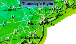
Partly sunny and cold. Highs in the upper 30s. West winds at 10-15mph.
Tonight:
An isolated snow shower early, otherwise clearing skies. Cold. Lows in the upper 20s in the City, the mid 20s inland. West winds at 10-15mph.
Friday:
Mostly sunny and cold. Highs in the upper 30s.
Saturday:
Sunny and cold. Highs in the mid 30s.
Sunday:
Mostly sunny and cold. Highs in the mid 30s.
Monday:
Party sunny and cold. Highs near 40º.
Keep it here for a no nonsense, no hype forecast.