Synopsis:
We will get a much deserved break from all of the rain of the last few weeks. The next five days will be precipitation free. It will be getting colder in steps. Today will be the warmest day with highs in the upper 50s. Colder air will filter in from Canada tonight. Temperatures will then fall into the 30s by midweek as a Northwest flow prevails as a large high moves from the central portion of the nation to the East coast. The sun will dominate through the end of the week.
By next Sunday, all eyes will be on a Southern storm. Does it slide to our South and miss the region or does it come up the coast. Way to early to answer that question. Just be aware that JMW is monitoring the situation.
You know where to find a no hype, no nonsense forecast.
Stay tuned.
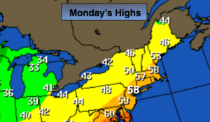
Today:
Mostly sunny and mild. Highs in the upper 50s. West winds at 15-25mph.
Tonight:
Partly cloudy. Much colder than recent nights. Lows in the mid 30s in the City, near 30º inland. Northwest winds at 10-15mph.
Tuesday:
Mostly sunny, colder. Highs in the lower 40s.
Wednesday:
Mostly sunny and cold. Highs in the upper 30s.
Thursday:
Mostly sunny and cold. Highs in the upper 30s.
Friday:
Mostly sunny and cold. Highs in the upper 30s.
Keep it here for a no nonsense, no hype forecast.