Synopsis:
High pressure will move off the coast today. This will allow moisture to move up from the South. Partly sunny skies will give way to mostly cloudy conditions by afternoon. It’ll become more humid.
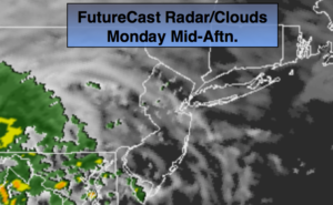
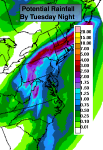
Florence, which is now an area of low pressure located over the central Appalachians, will move toward the Northeast tonight and Tuesday. Showers are possible late tonight. On and off rain and possible storms are likely on Tuesday. The rain could be torrential at times. One to two inches of rain is possible. If the bands of rain setup farther South into our area higher rain amounts would occur (map above).
Fine September weather will follow Wednesday through Friday.
You know where to find a no hype, no nonsense forecast.
Stay tuned.
Today:
Any morning sun will give way to mostly cloudy skies. Becoming humid. Highs around 80º. Southeast winds at 5-10mph.
Tonight:
Cloudy with scattered showers. Muggy. Lows in the lower 70s in the City, the upper 60s inland. Light Southeast to South wind.
Tuesday:
Periods of rain and thunderstorms. Humid. Locally heavy rain possible. There will be dry times. Highs in the upper 70s.
Wednesday:
Mostly sunny. Highs around 80º.
Thursday:
Mostly sunny. Highs in the mid 70s.
Friday:
Partly sunny. Much warmer. Highs in the lower to mid 80s.
Keep it here for a no nonsense, no hype forecast.